Karten von Theostelos: Unterschied zwischen den Versionen
Aus www.erkenfara.com
Alle Karten, die ich finden konte. :-) |
Keine Bearbeitungszusammenfassung |
||
| (9 dazwischenliegende Versionen von 3 Benutzern werden nicht angezeigt) | |||
| Zeile 4: | Zeile 4: | ||
== Erkenfara-Info, 1992 == | == Erkenfara-Info, 1992 == | ||
[[Datei:Askatia-Archiv.jpg|400px|thumb|left| | [[Datei:Askatia-Archiv.jpg|400px|thumb|left|Theostelos, Erkenfara-Info 1992]] | ||
[[Datei:EI92-073.jpg|400px|thumb|left| | [[Datei:EI92-073.jpg|400px|thumb|left|Theostelos, Erkenfara-Info 1992]] | ||
[[Datei:Ashidba.PNG|400px|thumb|left| | [[Datei:Ashidba.PNG|400px|thumb|left|Ashidba, die umkämpfte Insel, 1992]] | ||
{{clear}} | {{clear}} | ||
| Zeile 12: | Zeile 12: | ||
== Erkenfara-Info, 1994 == | == Erkenfara-Info, 1994 == | ||
[[Datei:Karte_Theostelos 1994.PNG|400px|thumb|left| | [[Datei:Karte_Theostelos 1994.PNG|400px|thumb|left|Theostelos, Erkenfara-Info 1994]] | ||
{{clear}} | {{clear}} | ||
| Zeile 18: | Zeile 18: | ||
== Teile der großen Karte == | == Teile der großen Karte == | ||
=== Theostelos === | === Theostelos === | ||
[[Datei:Theostelos_Karte.png|400px|thumb|left| | [[Datei:Theostelos_Karte.png|400px|thumb|left|Theostelos]] | ||
{{clear}} | {{clear}} | ||
=== Provinz Askatia === | === Provinz Askatia === | ||
[[Datei:Karte_askatia.png|400px|thumb|left| | [[Datei:Karte_askatia.png|400px|thumb|left|Askatia]] | ||
{{clear}} | {{clear}} | ||
=== Nordwest === | === Nordwest === | ||
[[Datei:Karte_nord_west.png|400px|thumb|left| | [[Datei:Karte_nord_west.png|400px|thumb|left|Nordwest, Talima]] | ||
{{clear}} | {{clear}} | ||
=== Carmoth === | === Carmoth === | ||
[[Datei:Karte_carmoth.png|400px|thumb|left| | [[Datei:Karte_carmoth.png|400px|thumb|left|Carmoth]] | ||
{{clear}} | {{clear}} | ||
| Zeile 39: | Zeile 39: | ||
== Die neuen Karten == | == Die neuen Karten == | ||
=== Theostelos === | === Theostelos und Yaromo === | ||
[[Datei:Theostelos_Karte.jpg|400px|thumb|left| | [[Datei:Theostelos_Karte.jpg|400px|thumb|left|Theostelos, 2023]] | ||
{{clear}} | {{clear}} | ||
=== | === Provinzen === | ||
[[Datei: | |||
{| class="wikitable" | |||
|- | |||
| [[Datei:Nordwesten von Theostelos.jpg|400px|thumb|left|Nordwesten, 2023]]|| [[Datei:Nordosten von Theostelos.jpg|400px|thumb|left|Norosten, 2023]] | |||
|- | |||
| [[Datei:Südwesten von Theostelos.jpg|400px|thumb|left|Südwesten, 2023]]|| [[Datei:Südosten von Theostelos.JPG|400px|thumb|left|Sübosten, 2023]] | |||
|} | |||
{{clear}} | {{clear}} | ||
=== Santanien === | |||
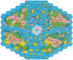
[[Datei:Santanien.JPG|400px|thumb|left|Santanien , 2023]] | |||
{{clear}} | |||
== Andere Reiche == | == Andere Reiche == | ||
=== Yaromo === | === Yaromo === | ||
[[Datei:Das-land-von-yaromo.png|400px|thumb|left| | [[Datei:Das-land-von-yaromo.png|400px|thumb|left|Yaromo 1993]] | ||
[[Datei:Karte_xahara.png|400px|thumb|left| | [[Datei:Landkarte yaromo.gif|400px|thumb|left|Yaromo bunt]] | ||
[[Datei:Karte_xalavas.png|400px|thumb|left| | [[Datei:Karte_xahara.png|400px|thumb|left|Xahara]] | ||
[[Datei:Karte_xarawin.png|400px|thumb|left| | [[Datei:Karte_xalavas.png|400px|thumb|left|Xalavas]] | ||
[[Datei:Karte_xeria.png|400px|thumb|left| | [[Datei:Karte_xarawin.png|400px|thumb|left|Xarawin]] | ||
[[Datei:Karte_xeria.png|400px|thumb|left|Xeria]] | |||
{{clear}} | {{clear}} | ||
=== Northeim === | === Northeim === | ||
[[Datei:Northeim.png|400px|thumb|left| | [[Datei:Northeim.png|400px|thumb|left|Northeim]] | ||
{{clear}} | {{clear}} | ||
=== Audvacar === | === Audvacar === | ||
[[Datei:Audvacar.png|400px|thumb|left| | [[Datei:Audvacar.png|400px|thumb|left|Audvacar, 1991]] | ||
[[Datei:EI91-017.jpg|400px|thumb|left| | [[Datei:EI91-017.jpg|400px|thumb|left|Audvacar, 1991]] | ||
{{clear}} | {{clear}} | ||
=== Vir'Vachal === | === Vir'Vachal === | ||
[[Datei:EI92-044.jpg|400px|thumb|left| | [[Datei:EI92-044.jpg|400px|thumb|left|Vir'Vachal, 1992]] | ||
[[Datei:Vir'Vachal 1992.PNG|400px|thumb|left| | [[Datei:Vir'Vachal 1992.PNG|400px|thumb|left|Vir'Vachal, 1992]] | ||
{{clear}} | {{clear}} | ||
| Zeile 80: | Zeile 92: | ||
== Sonstiges == | == Sonstiges == | ||
[[Datei:Ressourcen.png|400px|thumb|left| | [[Datei:Ressourcen.png|400px|thumb|left|Verteilung natürlicher Vorkommen [[Ressourcenkarten|häufiger Ressourcen]]<br>Erfolgreich verschlüsslt: Nur Yaromesen können das lesen]] | ||
[[Datei:Karte erkenfara bunt klein.png|400px|thumb|left| | [[Datei:Karte erkenfara bunt klein.png|400px|thumb|left|Bunt, klein, 880 × 739 Pixel]] | ||
[[Datei:Piratennest.png|400px|thumb|left| | [[Datei:Karte erkenfara bunt gross.png|400px|thumb|left|Bunt, groß, 2.513 × 2.111 Pixel, gut zum herunterladen]] | ||
[[Datei:2009 - Erkenfara.png|400px|thumb|left| | [[Datei:Piratennest.png|400px|thumb|left|Piratennest]] | ||
[[Datei:Erkenfara - farbig.png|400px|thumb|left| | [[Datei:2009 - Erkenfara.png|400px|thumb|left|2009]] | ||
[[Datei:Erkenfara - farbig.png|400px|thumb|left|farbig, 1.015 × 860 Pixel]] | |||
[[Kategorie:Theostelos]] | |||
[[Kategorie:Geographie]] | |||
Version vom 8. Juni 2024, 13:02 Uhr
Bibliothek von Theostelos, die Karten-Abteilung
Erkenfara-Info, 1992


Erkenfara-Info, 1994

Teile der großen Karte
Theostelos

Provinz Askatia

Nordwest

Carmoth

Die neuen Karten
Theostelos und Yaromo

Provinzen
 |
 |
 |
 |
Santanien

Andere Reiche
Yaromo


Northeim

Audvacar


Vir'Vachal


Sonstiges

Erfolgreich verschlüsslt: Nur Yaromesen können das lesen